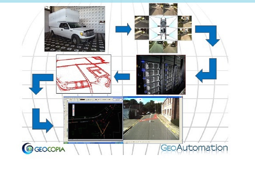
GeoAutomation™ has developed a mobile-mapping system that enables the capture of efficient and accurate measurements that can be imported directly into GIS systems. To do this GeoAutomation™ uses a recording system, mounted on top of a vehicle or other platform.
The key to Geoautomation´s innovation lies in pixel recognition, a technology developed by the researchers of the University of Leuven, who joined forces with a Belgian surveying company to create this exciting new innovation. It is not reliant on GPS and allows for the efficient capture of accurate measurements.
Image-based mobile mapping
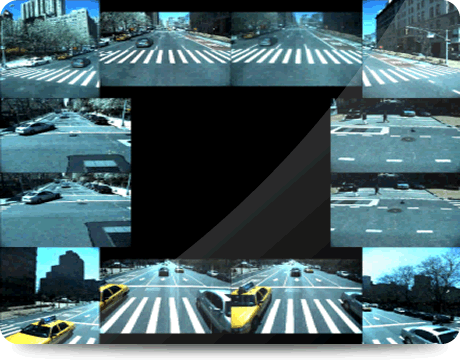
GeoAutomation™ disposes of a recording system, mounted on a vehicle and other platforms. The standard configuration contains 14 & 16 cameras, 2 & 8 Mgpixels resolution that can be oriented to suit the customer‘s needs - more cameras and systems can be provided to meet project specifics.
The GeoAutomation pipeline from capturing the images to processing and surveying at your finger tips consists of the following steps:
- Recording drive-through
- Automatic processing of the recorded imagery into a 3D reconstruction
- Geo-referencing of the result by means of ground control points or other reference systems
- Surveying & measuring into your GIS system, based on the 360° view images
- Surveying on the Web will be available soon
An approach based on vision
The GeoAutomation™ system is unique in that it is completely vision based.
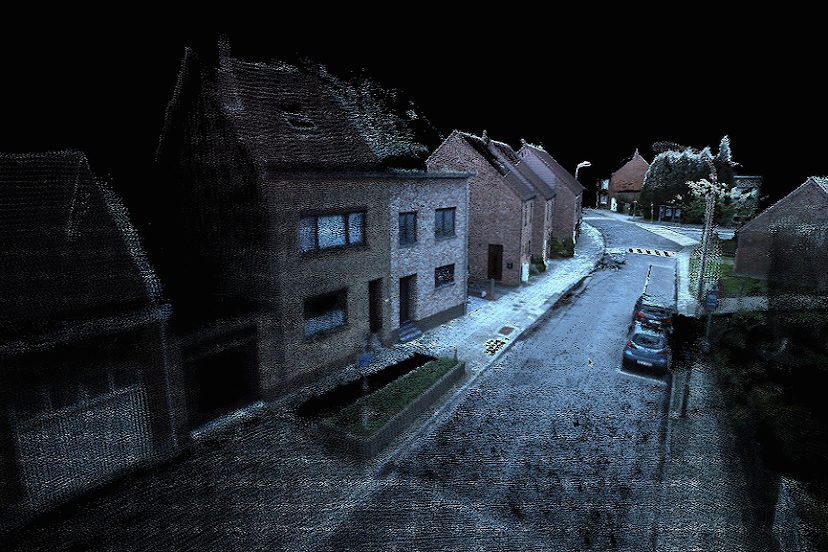
The ingenious positioning and quality of the cameras, as well as the high number of images allow GeoAutomation's innovative technology to automatically reconstruct an accurate 3D environment around the vehicle. It calculates the position and orientation of the recording system inside this environment (and hence becomes an IMU-like system). In this way, the position of every image is known within the 3D environment with a very high accuracy. Because the system is always 'inside' the reconstructed 3D environment, the result is very stable and there is no need for an additional (hardware) IMU. Many years of development have led to a fully automatic process that ties every vehicle position to reconstructed 3D points, both close and far. This guarantees stability: interpolation instead of extrapolation is used to compute the position and orientation of the vehicle.
The number of images is very high: they are recorded with a maximum interval of 1m (3feet)
GeoReferencing
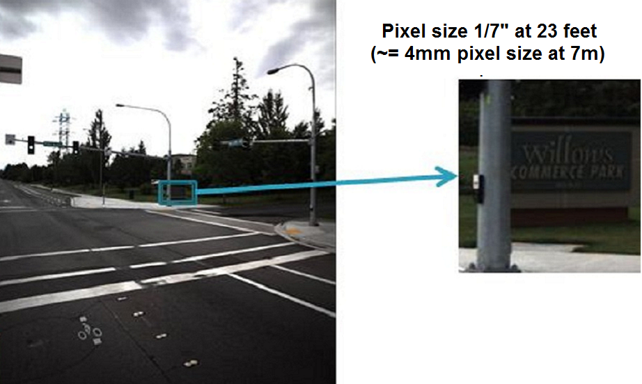
Highly calibrated 8/14/16 cameras, 2 to 8 Mgp and more for each trigger position. This results in a minimum of 28 Mgp for every meter (3 feet)! More important is what you see in this huge amount of data. With our camera constellation the ground resolution of the images is better than 4 mm (1/7 inch) at < 8 meters (24 feet) from the camera. Our high trigger frequency ensures that this ground resolution is achieved for every point on the street surface and its surroundings. At 20 meters (60 feet) from the cameras, resolution is still better than 1.2cm (1/2inch").
With GeoAutomation™ technology, less field completion is required! The frequency and angle of views also ensures that every element is seen from different angles and cameras and in many subsequent images. There's very little that you can miss!
After linking ground control points (GCP) to the 3D environment and using an advanced bundle adjustment, both the 3D environment and the system positions and orientations are known in the coordinate system of the GCPs. The accuracy of the 3D reconstruction is such that we can easily identify outliers in the GCP dataset, thus enhancing the final result.
Although the system is totally independent of GPS during the data captation, a high accuracy GPS antenna is integrated with the system which can be used to compute georeferenced solutions without GCPs or to reduce the number of GCPs required.
Surveying and Measuring
Automatically measure every point you see in the images with ease and precision. Just click the point you want to measure in one image, and the system will track the same point in neighboring images to give the resulting 3D coordinates automatically. Measure in manual mode for highest precision: clicking a point in separate images yields its 3D coordinates by means of a triangulation algorithm.
The automatically reconstructed 3D point-cloud can also be used for one-click surveying. Relative accuracy is better than 1 cm (1/2 inch). Absolute accuracy is available at < 2 cm (< 1 inch) for engineering grade accuracy requirements. GeoAutomation's user-friendly interface comprises plugins for MicroStation, AutoCad, ArcGIS, IntelliCad, ...

On and Off Road
When positioning is done using hardware devices like standard IMUs and odometers, the state of the road can have an impact on the resulting accuracy even in good GPS reception areas. Slippery roads, dirt tracks, bumpy or degraded roads are very demanding for these devices.
The GeoAutomation modeling system is based on the images from the surroundings. The road condition therefore has no influence on our results whatsoever. As a matter of fact, a degraded road gives more recognizable points for our image-based reconstruction software, which will only enhance the final result.
Whether it is on asphalted streets or not, underground, in parks or tunnels for Ports or airports GeoAutomation™ technology works consistently.
Indoor and Underground
GeoAutomation portable system with reduced dimensions can easily be used indoors. The technology stays the same. Cameras all around give the possibility to view, measure and reconstruct the complete indoor infrastructure. Extra cameras are added to give a better view on the ceiling.
The portable system similar to what we use for indoor is also great for mapping parcs, small alleys, bike roads, walkways, sidewalks and all other places not reachable with a vehicle.
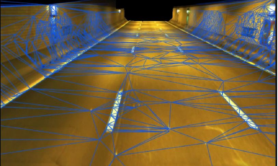
Tunnels
We work with images, so evidently we need some light to operate. But once we have enough light, the GeoAutomation system can be used in tunnels. If there is only a small amount of light, we can work with reduced speed to be able to use longer shutter times. The amount of field work will greatly reduce, limiting the time the tunnel is not available for its normal use.
Surveying Software Plugin
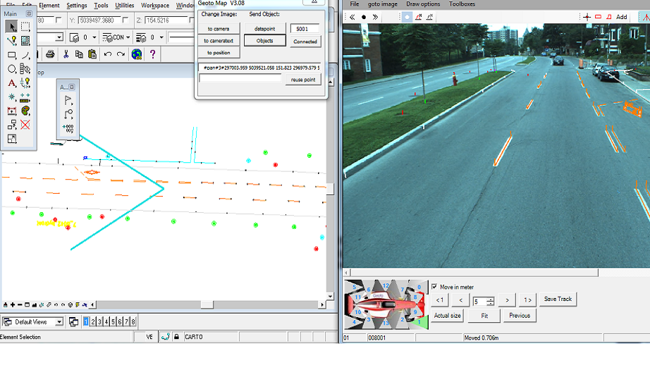
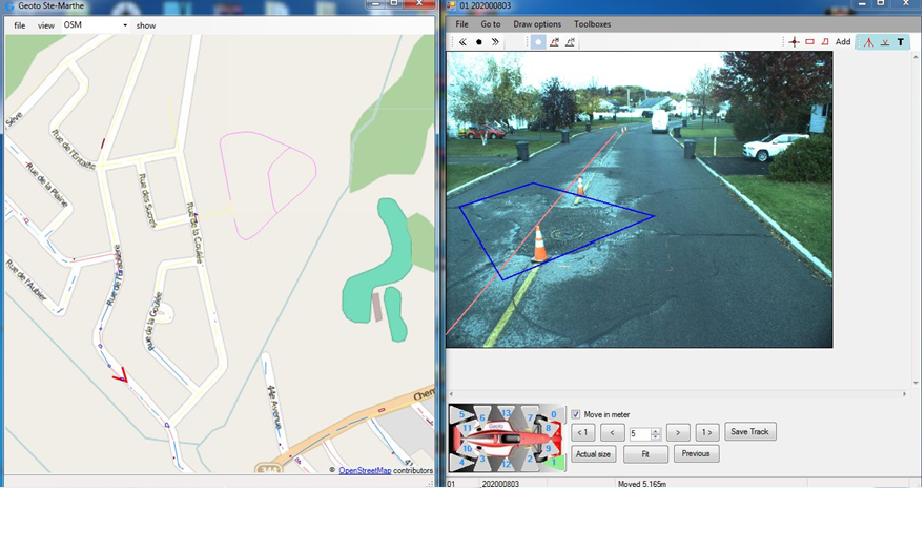
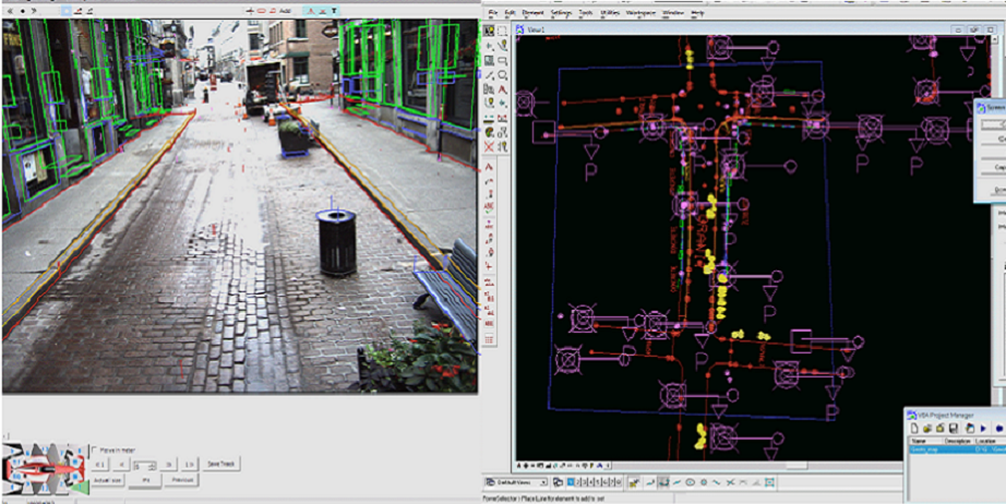
The GeotoMap software is your perfect tool to explore the images. It contains all necessary tools to view, navigate and measure in the images from within your existing GIS or CAD environment. The main features of the software are:
- Drive and navigate through the images: move in all directions, switch cameras, etc. Your map environment will follow all your moves.
- Get images for a certain location: select your location in your map environment, GeotoMap shows you the images for this location.
- Overlay mapping data on the images: this is the perfect way to validate your current mapping data. By visualizing your existing data in the images, you can compare your map with the real world situation.
- Measure in the images: measure positions, distances, heights, surfaces and many other objects or elements accurately.
- Collect new data: every point or object you see in the images can be measured. The resulting coordinates are sent automatically to your mapping environment where they are added to your active layer or command.
- Mapping history: GeotoMap saves your measurements for all data you collect. In this way every mapped object is linked to its own images.
Currently, GeotoMap is linked to Microstation™, AutoCad™, ArcGIS™, IntelliCad, OpenJump, Atlas, Jmap. For others, please call us
GeoToOSM


For Managers and non-technical people, we provide an easy way to access, measure and validate using our images. The GeoToOSM software is a perfect tool to explore the images for non technical personnel. It contains all the tools to view, navigate and measure in the images without a CAD or GIS environment. The main features of the software are:
- Drive and navigate through the images: move in all directions, switch cameras, etc. An integrated map environment, whether Open layers, Bing, ArcGIS-Online or other will follow all your moves.
- Search for Locations: select a location in your map environment, GeotoMap shows you the images for this location.
- Project mapping data on the images: this is the perfect way to validate your current mapping data. By visualizing your existing data in the images, you can compare your map with the real world situation.
- Measure in the images: measure positions, distances, heights, surfaces and many other object or elements accurately.
- Collect new data: every point or object you see in the images can be measured. The resulting coordinates are sent automatically to your map and to an export file.
- Mapping history: GeoToOSM saves your measurements for all data you collect. In this way every mapped object is linked to its own images.